Thursday, December 17, 2009

Chinese Communities in Western Siberia

Chinese immigrant communities were established in the Russian heartland (Western Siberia) during the interwar period (1920s-1930s). Chinese -primarily male groups - had managed to adapt peacefully, though temporarily, into the local environment due their particular mentality and social features: they were often occupying free labour and demographic lacunae, caused by the losses of men in WWI/Russian civil war and devastation of economy/infrastructure. The growth of authoritarian tendencies under the Stalinist regime in Soviet Union, economic shortcomings and the ethnic purges of 1930s closed the agenda of Chinese presence in the western Siberian, as well as in the whole Soviet scene. Actually all persons of Chinese origin were accused of being 'outside' (Japan's) collaborators, and they were assassinated or, at best, forwarded to concentration camps. Just a few survived. The Chinese in Western Siberia represented a very particular sociodemographic and ethnical phenomenon, remarkably distinctive from other similar, Russian Far East or worldwide, immigrant communities.  

Cross-border migrations between Russia and China are among the most actual problems of contemporary Russia-Chinese relations. Their history and dimensions have been shaped by the neighbouring positions of the two states and also by objective economic factors. The social-political situation on either side the border has also played a crucial role in determining the character, direction and 'algorythm' of these migrations. Historically it came about that the main form of migrational interaction between Russia and China was the movement of Chinese into the spacious regions of the Russian Far East and Siberia. The specifics of this presence, its socio-demographic structure and its possible consequences require further research and analysis. One element of such an analysis is the exploration of the history of Chinese immigration into Russia, specifically into West Siberia. We should note that this subject has not been well studied, either by Russian or foreign scholars, because of its political sensitivity and the lack of access to sources.

 At the end of the nineteenth and the beginning of the twentieth century, there were only just over 40,000 Chinese in the region. Very few of them lived in the southern and western parts of this vast area. The situation changed significantly during the years of the First World War and the 1920s. Hundreds and then thousands of Chinese migrants attached themselves to the hitherto tiny islands of Chinese scattered in the large cities of Western Siberia. They were mostly contract workers on war-related projects and seasonal workers. A great proportion of them were entirely taken up with the problems of their own survival, while others were directly drawn into the internal Russian military conflicts caused by the revolutionary events of 1917 and the deep crisis in the country. These Chinese migrants were mostly people from the lower social layers. They voluntarily entered the international brigades of the 3rd and 5th Red Armies, which were active at the time on the Eastern front. They revealed themselves to be brave fighters, which caused them to be much detested by their opponents. It is known that brutal punishments of Chinese prisoners of war from the Red Army were carried out by Kolchak's troops. In the winter of 1918, for example, at the station of Tyumen, two hundred people had their clothes removed and were then sent off naked to a distant prison camp. Only forty of them survived.

If you are interested, you can find more interesting and detailed information in the article presented by Mr. Boyko at the International Conference of Institutes and Libraries for Overseas Chinese Studies. 

Monday, December 14, 2009

Unique bridge crossing over Yuribey in Yamal

The bridge crossing over the Yuribey River, a part of the Obskaya – Bovanenkovo railroad. The Bovanenkovskoye field with its ABC1+C2 gas reserves totaling 4.9 trillion cubic meters is the largest gas field of Yamal. The new railroad thoroughfare designed to connect Yamal’s fields with the transportation infrastructure of northern Ural, will become a crucial component of the national strategic project – the Yamal Peninsula’s fields development. The year-round delivery of cargoes, equipment and workforce to develop Yamal will enable to rapidly form on the Peninsula a new gas production province of a fundamental importance for Russia’s gas industry development over the next decades.

This is a unique construction unparalleled in the global practice of bridge building. The crossing with the length of approximately four kilometers is the longest bridge beyond the Polar Circle. Its operating life accounts for 100 years. The bridge crossing over the Yuribey River floodplain is the most complicated section of the Obskaya – Bovanenkovo railroad. It is the world’s longest bridge beyond the Polar Circle and is unparalleled in the global bridge construction practice both in terms of design and the climatic and permafrost conditions of construction and operation (permafrost soil and high degree of bogginess). The crossing has the length of 3.9 kilometers, the total weight – over 30 thousand tons, the operating life – 100 years.

The most advanced technical solutions were applied during the construction process in the aim of preserving the floodplain ecosystem of the Yuribey River. In particular, the crossing was constructed avoiding the traditional deposition of soil, which enabled to retain the floodplain’s original environment.

The construction is mainly specific for the crossing arms. To secure their reliability the arms were made of 1.2–2.4 millimeters metal pipes, buried into the wells drilled under the permafrost conditions at the depth of 20–40 meters and filled with armored concrete. The innovative technologies developed by Russian scientists and engineers enable to protect the permafrost soil from thawing.

Source of information: Gazprom

Friday, December 4, 2009

Vegetation of West Siberia

Yurtsev (1994) states that this group " …covers the whole West Eurasian sector of the true Arctic (from 67° to 82° N); it is subdivided into [three] subprovinces, each corresponding to a major geomorphological unit. They form a natural swarm, its 'nucleus' being the mountain axis Ural-Pay Khoy-Novaya Zemlya, which runs through several vegetation zones from steppe into polar desert."
"The obvious negative features of the province are: the absence of (1) East Siberian, East Siberian-North American and North American species: (2) North Atlantic Hypoarctic and boreal species (and Arctic-alpine species such as Alchemilla alpina); (3) boreal and even boreal-nemoral taxa, e.g. Calluna vulgaris and Nardus stricta. There are few endemic and other differential taxa in the province or its subprovinces, i.a. Gastrolychnis angustiflora s.s., Papaver lapponicum ssp. Jugoricum, Pedicularis dasyantha, P. sudetica ssp. arcto-europea. The longitudinal floristic gradient is complicated by an 'inversion' in the Ural-Novaya Zemlya subprovince where the East Siberian species (and partly, the amphi-Atlantic) are better represented than in the adjacent lowland areas (Igoshina 1966). The presence of species of the genera Alchemilla, Euphrasia, Gnaphalium, Hieracium etc. is a distinctive feature of the Atlantic sector. The flora of this province was subjected to the destructive action of Quaternary marine transgressions and glaciations (Tolmachev 1970) as well as to the expansion of forest and shrub vegetation. Most favorable for the dispersal of Siberian and East Siberian continental elements was the cold and dry period of the Late Pleistocene, synchronous with the great sea regression." (From Yurtsev 1994.)
  • Karnin-Pechora sector: "Here we find most northward extensions of boreal species (in particular European), even on the Kolguyev Islands. The Arctic and Arctic-alpine complex is impoverished, endemism is very poor and of a low rank (e.g. Gentiana arctica, Koeleria pohleana). Some oceanic species penetrate, e.g. Calluna vulgaris, Ligusticum scoticum and Primula farinosa into the western parts of the subprovince and of continental species, e.g. Astragalus umbellatus, Salix nummularia and Trifolium lupinaster, into the eastern parts (of the Ural). Few East Siberian species—absent in the West Siberian lowland and present in the Ural Mts.—occur sporadically, e.g. Crepis chrysantha and Silene paucifolia." (From Yurtsev 1994.)

Gentiana arctica

  • Polar Ural-Novaya Zemlya sector : "The mountainous relief and the diversity of rocks and the expansion of forest and shrub vegetation favoured the preservation of various, sometimes contrasting flora elements. The barrier function of this mountain chain between the Siberian and European floras was of less importance. The montane floras of the [sector] typically show the floristic features of the Nenetsk province: European and amphi-Atlantic oceanic on one hand, and Siberian (boreal, continental Arctic, Arctic-alpine and Hypoarctic species) on the other, coexist. This subprovince includes the western foothills of the Polar Ural Mts. east of the 'Ruprecht line' (Rebristaya 1977) and is characterized by the highest richness within the province. This is due to: (1) overlapping distribution areas of western and eastern species; (2) far southward extensions of Arctic and even High Arctic species; (3) a distinct longitudinal floristic gradient (differences between the European and Asian slopes of the mountain range) and a more gradual latitudinal gradient. Several endemics arose from hybridization between Siberian and European taxa, e.g. Trollius x apertus = T. europaeus x T. asiaticus. The level of endemism is slightly higher here than in the adjacent subprovinces. Endemics of East Siberian affinity are e.g. Astragalus gorodkovii, A. igoshinae and Taraxacum platylepium." (From Yurtsev 1994.)

Trollius apertus

  • Yamal-Gydan sector: "This [sector] contrasts with the previous [sector] in terms of a low floristic richness in association with various negative features of its flora: the gap in the distribution areas of many montane, predominantly East Siberian species; the absence of scores of 'eastern' (trans-Yenisey) species along with western ones (European, amphi-Atlantic, etc.) reaching the Ural Mts. Many 'western' species are confined to the lower Ob drainage up to the Taz Peninsula, and are lacking in the Gydan Peninsula; some of them are also recorded outside the Arctic from the mountains on the right bank of the Yenisey River. Most of the western elements are restricted to the southernmost areas whereas the role of the eastern counterparts increases northwards. Endemism is almost totally lacking here." (From Yurtsev 1994.)


Via Toolik-Arctic Geobotanical Atlas (TAGA)

Thursday, December 3, 2009

Siberian Cuisine

We can not talk about Siberia without saying some words about Siberian cuisine. It differs from all the others throughout the world. The Siberian cuisine has ancient origin and old culinary traditions. Siberian dishes spread throughout the country only after construction of railway in Siberia.

Genuine Siberian cuisine is a combination of meat, game, fish and unique taiga seasoning. One of the popular Siberian dishes is pelmeni dumplings, which are famous all over Russia. Most of the Siberians prepare plenty of pelmeni dumplings at once and put already frozen dumplings into linen sacks. Whenever you want, you can just put them into the boiling water and in several minutes, the tasty dish is ready.

Due to the fact that Northwestern Siberia is plenty of rivers and lakes, fish is a main part of the typical cuisine. There are about 50,000 rivers in the territory of the Yamalo-Nenets district. All of them belong to the Kara sea basin: Taz, Pur, Nadym, Messoyakha. There are also 300,000 lakes here with Piakuto, Yaroto, Neito and Nembuto as the main ones. The rivers' basins supply more than a half of all Russian fish, being  sturgeon, Siberian white salmon (nelma), whitefish (muksun) and arctic cisco (omul) the best kwon fishes.

People of Northern Russia know that eating food raw, as it is, or better to say as it was in nature, can be very beneficial to their health. The only problem is that the only food available during long polar nights in raw state in these lands is meat and blood - the flesh of the freshly killed deers they breed. So, they eat it as it is - raw and uncooked. People say, that this is the only source of vitamins, especially vitamin C for them, and due to this habit they maintain to survive in severe Northern climates for hundreds of years.

Stroganina, a kind of Siberian sashimi, is the crown of the Siberian cuisine treasures. It is thin, crisp slices of fresh frozen fish seasoned only with salt and pepper and traditionally served with vodka.


Tuesday, December 1, 2009

How dependent is Europe on Russian gas?

Based on Pierre Noel´s report, until the early 2000s, most of Europe’s gas imports came via pipelines. But over the past decade, Europe has become a major customer in the rapidly growing market for liquefied natural gas (LNG), which is transported by sea. Since 2002, LNG from new suppliers such as Nigeria, Egypt, Trinidad or Qatar has accounted for most of the rise in EU gas imports. The share of LNG in EU gas imports has grown from 15% in 2000 to more than 20% in 2007. Even pipeline routes from Russia itself have diversified: the “Yamal-Europe” pipeline, which was opened in the 1990s, has reduced reliance on the Ukrainian corridor.There may be no problem of European overdependence on Russian gas, but this is not to say that all is well on the supply front. Over the next 15-20 years, Gazprom faces serious supply challenges, and the international gas market is likely to experience considerable tightening. These issues, combined with declining indigenous production, mean that in the coming decades Europe could face a gas supply crunch, leading to stagnant or even declining consumption.


Despite controlling the world’s largest gas reserves, Gazprom will find it difficult to maintain its current supply levels. Production from the three “super-giant” west Siberian gas fields, which account for the bulk of Gazprom’s output, is now in steep decline. The company’s ability to maintain, let alone increase, production in the coming decades depends on the development of a new generation of fields on the Yamal Peninsula in northwest Siberia. Gazprom’s official line is that Yamal will come on stream in 2010. But independent analysts and most of the European gas industry think this is highly unlikely. Some mention 2015 as a more realistic date for Yamal’s completion.

In fact, Gazprom’s production is already insufficient to meet all the company’s commitments. It depends on two other sources of gas – “independent” Russian producers and imports from Central Asia, especially Turkmenistan – to make up the shortfall. This “bridge” is supposed to supply Gazprom’s needs until the Yamal fields come online. But there is uncertainty over whether Gazprom will be able to source sufficient volumes from Turkmenistan, while independent Russian producers have little incentive to increase their production in the absence of access to Gazprom’s transmission network, which would enable them to reach consumers directly. Moreover, domestic gas consumption in Russia is growing, driven by economic expansion and a gas-intensive electricity mix. So there is at least a risk that Gazprom’s “bridge” to Yamal could collapse. Industry assessments vary from a tight but manageable supply situation to an impending crisis.

As long as Gazprom relies on the Turkmen/independent supplier “gas bridge”, it is unlikely that exports to Europe, at least those under long-term contracts, will increase at all. Depending on how quickly Gazprom can get the Yamal fields on stream, there could be room for increased exports to Europe in the second part of the next decade, though any additional commitments are unlikely to be large. In 2006, major long-term contracts with European importers were renewed until 2030-3514; as west Siberian production declines, these contracts will be serviced increasingly from Yamal, limiting the volumes available for new contracts. Finally, Russia’s political willingness to expand exports to Europe beyond current levels remains unclear.

Sources: EU Energy Policy Blog and The European Council on Foreign Relations

Thursday, November 26, 2009

Climate change and forest distribution

Treeline questions have been studied from a number of different perspectives, but nearly all are at least implicitly connected with the question of how cold temperatures limit tree growth and survival. Because of this overriding interest in temperature limits, and because of the ubiquitous occurrence of treelines across the Arctic and the high state of preservation of dead trees in the cold environment of the Arctic, treeline studies have much to offer on the specific question of climate warming and cooling.
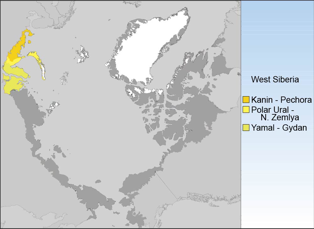
Holocene wood deposits in the southern Yamal Peninsula include a large quantity of subfossil tree remains, including stems, roots, and branches. This is the result of intensive accumulation and conservation of buried wood in permafrost. In these conditions tree remains conserved in peat sediments were direct evidence that the northern treeline in the warmest period of the Holocene reached the central regions of the Yamal Peninsula (up to 70° N). Today the polar treeline is considerably further south on the Peninsula (67°30’ N).
Systematic collection of subfossil wood samples started in 1982 in the watersheds of the Khadyta, the Yadayakhodiyakha, and the Tanlova Rivers in the southern Yamal Peninsula. River flow in this area is from north to south, excluding the possibility that wood was transported to the collection site from more southerly locations; thus, there is very high confidence that the region experienced a considerably warmer summer climate in the relatively recent past.

Radiocarbon dating of the subfossil wood (53 dates) was cross dated with ring series from the samples, allowing the construction of a continuous tree-ring chronology 7,314 years in length. Absolute dates can generally be assigned to the recovered wood remains. The result makes it possible to reconstruct the dynamics of tree limits on the Yamal Peninsula during the Holocene, as the following figure displays.

From at least 10,000 to 9,000 years BP, trees grew across most of the Peninsula. The most favorable conditions for tree growth (almost certainly warm summers) occurred from 7200 to 6000 BC. From about 6000 to 5600 BC, climatic conditions became less favorable for tree growth (almost certainly cooler summers), but trees persisted and did not retreat to the south. Beginning about 5400 BC, trees were displaced southward. The forest stand density also greatly decreased during this period, and it can be considered as a transition to the next stage of the Holocene. From 5400 until 1700 BC, the polar treeline was still located at 69° N, well north of the present-day position. In unfavorable periods (4500–3900 BC and 3600–3400 BC), tree survival was mainly restricted to the river corridors, but in climatically more favorable periods (5200–4500 BC, 3900–3600 BC, and 3400–1800 BC), forests grew on hills and raised surfaces beyond the rivers.

ne of the most important periods of displacement of polar treeline to the south and major reduction in the density and productivity of forest stands occurred about 1700 BC. This stage can be regarded as the end of the Middle Holocene and the beginning of the modern stage of treeline evolution on the Yamal Peninsula. During the last 1,700 years, forest–tundra and forest associations have been primarily restricted to river valleys in the southern part of the Peninsula. Somewhat more favorable conditions occurred from 1200 to 900 BC, from 100 BC to AD 200 and during the Medieval Warming Period (MWP) (AD 700–1400).

Treeline dynamics for the last 4,000 years of the Holocene were reconstructed with even greater precision using more than 500 cross-dated tree stems with known coordinates of their burial places in valleys of different rivers on the southern-Yamal Peninsula.

Treeline displacements northward and southward were relatively small and less important during the last 3,600 years than those that occurred in the previous few millennia. Treeline generally moved at the most 5 km to the south of the present-day treeline, and subsequently northward only to the present boundary of open woodland in the river valleys. However, one particularly noteworthy major displacement of treeline to the south occurred during the second half of the 17th century BC. In this relatively short period (not exceeding 100 years), the boundary of larch open woodland moved southward nearly 15 to 20 kilometers (km), and the treeline retreated a further 8 to 10 km during the next 700 years. This major displacement of treeline in the 17th century BC appears to have been driven by strongly inclement climatic conditions (cold summers), representing the lowest reconstructed summer temperatures in the entire series. It was in the years immediately after 1657 BC that the temperature decreased sharply. Fourteen years during the interval 1630 to 1611 BC appear to have been extremely cold, reaching a nadir in two specific years, 1626 and 1625 BC. No other period during the reconstruction is even close. Moreover, it is clear that in 1625 BC, a severe freeze occurred in the middle of the summer (as indicated by characteristic anatomical structures of freeze injury in the tree rings). It is very probable that this short-term extreme climate event represented climate cooling following one of the largest volcanic eruptions of the last few millennia, which happened in about 1628 BC (possibly the eruption of the Santorini volcano in the eastern Mediterranean). The cooling appears to have reinforced another closely spaced cooling event that preceded it. The earlier of the two periods of extreme cold temperatures began sometime after 1657 BC, but in this case, it is difficult to determine the cause. These events were the final circumstances that resulted in the most significant southward retreat of treeline during at least the last 4,000 years. In spite of extremely favorable summer warmth that returned afterward and even persisted at various intervals, the treeline never returned to its previous boundary.

Another important result of dendrochronological dating of large samples of subfossil wood is the ability to calculate the relative abundance of Siberian spruce in forest stands of the area, which is an index or proxy for the degree of continentality of the climate. The figure presented below shows the change in the proportion of spruce in forest stands (the remaining part is all larch). In the first six centuries, from AD 900 to 1500, the proportion of spruce decreased from 22% to 3–5%. After that, the percentage of spruce stabilized in the range of 7-10%. The 20th century is characterized by an increasing percentage of spruce in forest stands in the valley of the River Khadytayakha, and a weak northward advance of the polar treeline.

If you are interested about climate change and forest distribution in Artic regions, visit "The Encyclopedia of Earth" for further information about this topic in other regions.

Wednesday, November 25, 2009

Vast amounts of methane will explode into the air in Russian tundra

The snows are late in coming on the Arctic Yamal peninsula where moist, dark permafrost entombed for 10,000 years crumbles into the sea at the top of the world. Western scientists and environmentalists say collapsed river banks, rising tide waters and warmer winters in northwest Russia are clear signs of climate change, but they add Russia is in denial, ignoring a potentially disastrous “methane bomb”.

But for Alexander Chikmaryov, who works in the state-run meteorological station at the Marresale port on the Kara Sea, around 500 km north of the Arctic Circle, global warming does not exist: “Whoever made that ridiculous idea up spends too much time at home,” said the 58-year old, surveying an exposed strip of permafrost from a mud bank that has collapsed, giving way to streamlets littered with goose skeletons.

Geographer Fyodr Romanenko of Moscow State University agreed there is no proof human activity has damaged the environment. The up to 4 degree Celsius rise felt across parts of the Arctic in the last 30 years could be part of millennia-old fluctuating weather patterns, he said. Other researchers disagree, saying the frozen, sparsely populated Yamal region 2,000 km northeast of Moscow holding a quarter of the world’s known gas reserves and home to the Nenets tribespeople, is testament to climate change.


According to a paper in the scientific journal Global Change Biology published by Bruce Forbes of Finland’s Arctic Centre, rising temperatures are making the Arctic tundra greener, adding significant growth of shrub willows over the last thirty years.


MELTING PERMAFROST

The world’s largest country has a thick band of permafrost — which contains organic matter whose microbes can emit the powerful greenhouse gas, methane — stretching from Murmansk near Finland to the far eastern region of Chukotka near Alaska.

Environmentalists fear melting permafrost from rising temperatures will accelerate global warming. Russia — which has permafrost covering 60 percent of its land — most likely holds the world’s biggest methane threat. By 2050, vast amounts of methane will “explode into the air” from Russia’s melting permafrost, Chuprov, head of the Russian energy unit at environmental group Greenpeace, said.


Atmospheric methane concentrations, 1985-2008, with the IPCC methane projections overlaid

(adapted from: Dlugokencky et al., 2009)


The United Nations panel of climate scientists says warming is happening faster in the Arctic than the global average. As reflective snow and ice retreats, it exposes darker ground and water that soaks up ever more heat.

Monday, November 23, 2009

Climate change: Yamal tree rings II. Discussion

As we explained in our previous post, a great controversial was opened about climate change researches based on tree rings of Yamal area, published in Science. A large number of peer-reviewed climate papers have incorporated data from trees at the Yamal Peninsula in Siberia. This dataset gained favour, curiously superseding a newer and larger data set from nearby. The older Yamal trees indicated pronounced and dramatic uptick in temperatures.

Scientists have ensured much of the measurement data used in the reconstructions remains a secret - failing to fulfill procedures to archive the raw data. Without the raw data, other scientists could not reproduce the results. The most prestigious peer reviewed journals, including Nature and Science, were reluctant to demand the data from contributors. Until now, that is.

Yamal data set uses just 12 trees from a larger set to produce its dramatic recent trend. Yet many more were cored, and a larger data set (of 34) from the vicinity shows no dramatic recent warming, and warmer temperatures in the middle ages.

In all there are 252 cores in the CRU Yamal data set, of which ten were alive 1990. All 12 cores selected show strong growth since the mid-19th century. The implication is clear: the dozen were cherry-picked.


The catch, discovered by Mc Intyre (visit Cimate Audit), is that scientists just choose the figures from a chronology of tree rings located in the Yamal Peninsula. However, there is a chronology for that area much more extensive , known as the chronology of Schweingruber.

Including the trees of previous datasets in Yamal, climate reconstruction showed a new hockey stick. However, using the chronology of Schweingruber, much more extensive and complete, it is  shown that the sharp rise in Arctic temperatures during the twentieth century completely disappears. It all depends on the timing system used in Yamal (in red) or in Schweingruber (blank).

The differences are even clearer if we analyze the evolution of temperatures from 1850: the Yamal data in red, black Schweingruber data.


That is, the report published in Science is false, as the authors have carefully selected the trees of a certain subgroup of more comprehensive data, identifying only those that showed soaring temperatures and discarding the rest.

The controversy has been included in many publications such as American Thinker, Financial Post, Examiner and National Post, among others.

Sunday, November 22, 2009

Climate change: Yamal tree rings I. Background

Yamal Peninsula has recently become famous due to controversial in climate change researches. A recent article in the prestigious journal  Science reconstructs the Arctic average temperature over the last two millennia. The report shows a brutal oddly soaring temperatures in the twentieth century.

Jump back scientific controversy about the dreaded global warming. The climate change summit in Copenhagen (Denmark) this December is approaching and with it come new studies to justify the threat of polluting gases emissions (CO2) by man into the atmosphere.

The report shows a brutal oddly soaring temperatures in the twentieth century. A new hockey stick based on data provided by tree rings from the Yamal Peninsula in Siberia, as a witness in climate.

The target de jour is a particular compilation of trees (called a chronology in dendro-climatology) that was first put together by two Russians, Hantemirov and Shiyatov, in the late 1990s (and published in 2002). This multi-millennial chronology from Yamal (in northwestern Siberia) was painstakingly collected from hundreds of sub-fossil trees buried in sediment in the river deltas. They used a subset of the 224 trees they found to be long enough and sensitive enough (based on the interannual variability) supplemented by 17 living tree cores to create a “Yamal” climate record.

A preliminary set of this data had also been used by Keith Briffa in 2000 (pdf) (processed using a different algorithm than used by H&S for consistency with two other northern high latitude series), to create another “Yamal” record that was designed to improve the representation of long-term climate variability.

Popularized by Al Gore, the hockey stick graph shows a precipitous rise in global temperatures over the last few decades. Using the hockey stick graph as a base, Gore extrapolated the data to claim that catastrophic temperature change (with all of its deleterious effects) was around the corner. This claim has been adopted with religious zeal by some scientists, almost all international politicians, and the Obama administration. As a consequence, massive worldwide policy initiatives are being developed. The question is—are they being developed to solve a problem that has been improperly characterized and incompletely understood.

As for assessing the significance of 20th century global warming, the evidence from dendroclimatology in general, supports the notion that the last 100 years have been unusually warm, at least within a context of the last two millenia. However, this evidence should not be considered equivocal. The activities of humans may well be impacting on the 'natural' growth of trees in different ways, making the task of isolating a clear climate message subtly difficult.

This long-term trend was caused by the steady orbitally driven reduction in summer insolation. The cooling trend was reversed during the 20th century, with four of the five warmest decades of our 2000-year-long reconstruction occurring between 1950 and 2000.

All these studies have been disqualified due to the data set used to conduct such research. In following post we will give further information about the controversial of Yamal tree rings, explaining more about this scientific affair.

Wednesday, November 18, 2009

Railroad of Death

Salekhard–Igarka Railway, referred to variously as 501 Railroad or Railroad of Death, was a project of the Soviet Gulag system that took place from 1949 to 1953. It was part of a grand design of Joseph Stalin to span a railroad across northern Siberia to reach the Soviet Union's easternmost territories. The connection from Igarka to Salekhard measured 806 miles (1,297 km) in length. The project was built mostly with prisoner labor, particularly that of political prisoners, and thousands perished.


"The might of Russia will grow with Siberia", Mikhaylo Lomonosov said about riches of our region. But roads are necessary for mastering such big territory. Rivers served as roads for first explorers. It was possible to get to the river Ob and the river Yenisey from Ural slopes, along the system of river floods. People came here for different fur, pelts and walrus bone. But short northern summer restricted drifting along rivers and the North Sea Route. 

In the end of the XIX century and in the beginning of the XX century the projects were denied for want of means and manpower. The drastic development of camp system under Stalin enabled to realize the colonization of remote areas and projects within industrialization campaign.


It was hard to build the road. Big amount of sand was swallowed by swamps, unexpected floods washed and ruined the ready road. Only complete persistence of workers could help to move the building forward. To stimulate the active work of convicts, the chief of the building the colonel V.A.Barabanov input the system of reckoning: for one who carries out the day norm on 115% - to count it as for two days, on 125% - as for three days. Some convicts owing to such system could decrease the time of their imprisonment on 1,5-2 years. Of course, hard work in severe conditions was not possible to do for all people, some of them fell ill and died. The common mischief for everybody was mosquitoes, midges, horseflies and other bloodsucking insects. In summer there was no rescue from it. There were cases of suicide of sentries even. But constantly appearing technical problems for leaders of the building were worse than mosquitoes. After war there was not enough amount of rails. They had to bring ruined remains of rails from battlefront railroads. They were cut in special shops to one-meter pieces and welded to ten-meters rails.


1950 - building the road was continued in growing tempos. Reports about regular progress went to Moscow, the bridge over the river Nadym was built, trains started moving to the west…But as the final day of the building was coming closer, more obvious became the fact that it was not so necessary: there was nothing and nobody to transport along these desert Polar lands. Probably Stalin himself understood untimely character of building, which had been started by his initiative. Starting with 1952 the amount of work on the road Salekhard-Igarka was gradually decreased. People, equipment and materials were sent to other objects, more necessary for the country.


In the following links you can find further information about Stalin's dead railway:

"The Dead road": an overview about the project.

English Russia: photo gallery.

Tuesday, November 17, 2009

Nadym site of ancient settlement

In 1997 prospecting works and excavations of the archeology monument "Nadym site of ancient settlement" (Nadymskoe gorodishehe) began. The results of the research speak of the rarity and unique characters of the monument; scientists compare it with the discoveries of Ancient Novgorod (Drevny Novgorod). 

Dendrochronological research showed that the beginning of functioning of the site can be traced back to the end of the XI century. The permafrost provides splendid preservation of organic substances: wood, leather and cloth. Cultural layer of the site abounds in various finds made of mammoth bones, iron, copper, bronze such as decorations, arrow tips, handles and blades of knifes and sables, spoons, wooden and bark dishes, children's toys, whistling play-birds remaining from ancient Russian sailing-ships - the so called "kotches".

Find further information in Nadym Museum and Nadymskiy gorodische (both in Russian).

Tuesday, November 10, 2009

Gas and oil in Yamal

The Yamal Peninsula is a strategic oil- and gasbearing region. Commercial development of fields onshore and offshore Yamal is crucial for securing Russia's gas production. Althought Yamal is the primary source for oil and gas, Western Siberia is plenty of hydrocarbon resouces, as shown in the following image (via Blackburn Geoconsulting)


According to regional predictions, by 2012, a total of 638,6 billion cubic meters of gas will be produced in the region, much of which will be from the mighty Bovanenkovo field. Gazprom is about to install the first three rigs at its huge Bovanenkovo field in the Yamal Peninsula, with a total of nine rigs ready when production starts in late 2011. However, it is not all full steam ahead – the Yuzhno-Tambeyskoe gas field in the Yamal Peninsula will not now be started until 2024, Gazprom says, likely a disappointment to Shell and ENI, which both seek stakes in the project.

11 gas and 15 oil, gas and condensate fields with approximately 16 tcm of explored and preliminary estimated gas reserves (ABC1+C2) and nearly 22 tcm of in-place and forecast gas reserves (C3+D3) have been discovered on the Yamal Peninsula and in its adjacent offshore areas. Reserves of condensate (ABC1) are estimated at 230.7 mln t and those of oil – 291.8 mln t.

Gazprom Group holds the development licenses for the Bovanenkovskoye, Kharasaveyskoye, Novoportovskoye, Kruzenshternskoye, Severo-Tambeyskoye, Zapadno-Tambeyskoye, Tasiyskoye and Malyginskoye fields.

In terms of gas reserves (ABC1+C2) the Bovanenkovskoye field is the most significant one on the Yamal Peninsula (4.9 tcm). The initial gas reserves of the Kharasaveyskoye, Kruzenshternskoye and Yuzhno-Tambeyskoye fields amount to about 3.3 tcm.

The Yamal Peninsula will be a vital key for the development of the world’s gas industry over the next 50 years. Nowadays it gives 87 percent of Russia’s gas and 20 percent of the world’s gas, being specially significant in Europe, as the following figure and video display (via Gazprom).


Wednesday, November 4, 2009

Tundra biome

Yamal Peninsula and Northern West Siberia are located in the tundra biome, in the Paleartic ecozone. The tundra is a vast area of stark landscape, that covers a tenth of the Earth. The soil is frozen from 25–90 cm down; this phenomena is known as "permafrost". Instead, bare and sometimes rocky land can only support low growing plants such as moss, heath, and lichen. There are two main seasons, hardly cold winter and mild summer. During the winter it is very cold and dark, with the average temperature around −28 °C, sometimes dipping as low as −50 °C.


In terms of precipitation, the tundra is desert-like, with only about 15–25 cm falling per year. During the summer, the permafrost lets plants grow and reproduce, but because the ground below this is frozen, the water cannot sink any lower, and so the water forms the lakes and marshes found during the summer months. Although precipitation is light, evaporation is also relatively minimal.

The biodiversity of the tundras is low: 1,700 species of vascular plants and only 48 land mammals can be found, although thousands of insects and birds migrate there each year for the marshes. There main vegetation includes: low shrubs, sedges, reindeer mosses, liverworts, and grasses, 400 varieties of flowers crustose and foliose lichen.

 
All of the plants are adapted to sweeping winds and disturbances of the soil. Plants are short and group together to resist the cold temperatures and are protected by the snow during the winter. They can carry out photosynthesis at low temperatures and low light intensities. The growing seasons are short and most plants reproduce by budding and division rather than sexually by flowering.

There are few species with large populations. Notable animals in the Arctic tundra include caribou (reindeer), musk ox, arctic hare, arctic fox, snowy owl, lemmings, and polar bears (only the extreme north).

A severe threat to the tundras, specifically to the permafrost, is global warming. The melting of the permafrost in a given area on human time scales (decades or centuries) could radically change which species can survive there.


Another concern is that about one third of the world's soil-bound carbon is in taiga and tundra areas. When the permafrost melts, it releases carbon in the form of carbon dioxide, a greenhouse gas. 

Tuesday, November 3, 2009

Frozen Baby Mammoth found in Yamal

The six-month-old female calf was discovered on the Yamal peninsula and is thought to have died 10,000 years ago. The animal's trunk and eyes are still intact and some of its fur remains on the body. 

Mammoths are an extinct member of the elephant family. Adults often possessed long, curved tusks and a coat of long hair. The 130cm (4ft 3ins) tall, 50kg Siberian specimen dates to the end of the last Ice Age, when the great beasts were vanishing from the planet. 

It was discovered by a reindeer herder in May this year. Yuri Khudi stumbled across the carcass near the Yuribei River, in Russia's Yamal-Nenets autonomous district.

That specimen failed to yield DNA of sufficient quality, but some researchers believe it may only be a matter of time until the right find emerges from Siberia.

Bringing mammoths back from the dead could take the form of injecting sperm into the egg of a relative, such as the Asian elephant, to try to create a hybrid. Alternatively, scientists could attempt to clone a pure mammoth by fusing the nucleus of a mammoth cell with an elephant egg cell stripped of its DNA. 


But scientists warned that scientifically valuable Siberian mammoth specimens were being lost to a lucrative trade in ivory, skin, hair and other body parts. The city of Yakutsk in Russia's far east forms the hub for this trade. 

Local people are scouring the Siberian permafrost for remains to sell on, and  more carcasses could be falling into the hands of dealers than are finding their way to scientists.

The mysteries of her appearance on a frozen river bank in the Yamal, and the intersection of the people who tend to her, are the subject of National Geographic's Waking the Baby Mammoth documentary. In the following link you will be able to discover more about the discover of Lyuba. 

National Geographic documentary

Additionaly we suggest two short videos about this important archeological discover. In the first one we can watch the story of the discovery of the world's most complete baby mammoth, as told by the man who found her.

The second video gives an overview of the main results of the researches carried out.


Monday, November 2, 2009

Basic information (Western Siberia & Yamal)

Once we have given the major framework of our blog, it is time to give some basic information and figures about Western Siberia and Yamal Peninsula.

This region is characterized by a unique combination of severe climatic conditions, natural resources, an extremely vulnerable environment, and a multi-ethnic population. Geographically, Western Siberia is defined as the territory east of the Ural Mountains but west of the Yenisei River.


West Siberian Plain is located west of Ural Mountains. It covers an area of more than 975,000 sq.mi. It has been described as the world's largest unbroken lowland—more than 50 percent is less than 330 feet (101 m) above sea level—and covers an area of about 2.6–2.7 million km² which is about one third of Siberia, extending from north to south for 2,400 km, from the Arctic Ocean to the foothills of the Altay Mountains, and from west to east for 1,900 km from the Yenisei River to the Ural Mountains.

The plain has eight distinct vegetation regions: tundra, forest-tundra, northern taiga, middle taiga, southern taiga, sub-taiga forest, forest-steppe, and steppe. The number of animal species in the West Siberian Plain ranges from at least 107 in the tundra to 278 or more in the forest-steppe region. The long Yenisey river flows broadly south to north, a distance of 2,195 mi., where it completes its journey, discharging more than 5 million gallons of water per second. Together with it's tributary Angara, the two rivers flow 3,435 mi. The valley it has formed acts as a rough dividing line between the West Siberian Plain and the Central Siberian Plateau. Glacial deposits extend as far south as the Ob-Irtysh confluence, forming occasional low hills and ridges, but otherwise the plain is exeedingly flat and featureless.


Winters on the West Siberian Plain are harsh and long. The climate of most of the plains is either subarctic or continental. Two of the larger cities on the plain are Surgut and Nizhnevartovsk.

Russian researchers warn that Western Siberia has begun to thaw as a result of global warming. The frozen peat bogs in this region may hold billions of tons of methane gas, which may be released into the atmosphere. Methane is a greenhouse gas 22 times more powerful than carbon dioxide. In 2008, a research expedition for the American Geophysical Union detected levels of methane up to 100 times above normal in the Siberian Arctic, likely being released by methane clathrates being released by holes in a frozen 'lid' of seabed permafrost, around the outfall of the Lena River and the area between the Laptev Sea and East Siberian Sea.


The Yamal Peninsula, located in Yamal-Nenets autonomous district of northwest Siberia, Russia, extends roughly 700 km (435 mi) and is bordered principally by the Kara Sea, Baydaratskaya Bay on the west, and by the Gulf of Ob on the east. In the language of its indigenous inhabitants, the Nenets, "Yamal" means "End of the World".


The peninsula consists mostly of permafrost ground and is geologically a very young place —some areas are less than ten thousand years old.

In the Russian Federation, the Yamal peninsula is the place where traditional large-scale nomadic reindeer husbandry is best preserved. On the peninsula, several thousand Nenets and Khanty reindeer herders hold about half a million domestic reindeer. At the same time, Yamal is inhabited by a multitude of migratory bird species.


Yamal holds Russia's biggest natural gas reserves. The Bovanenkovskoye deposit is planned to be developed by the Russian gas monopolist Gazprom by 2011-2012, a fact which put the future of nomadic reindeer herding at considerable risk.

Friday, October 30, 2009

Climate change in Russia's Arctic tundra

Our expert David Pérez Cuenca has sent us a very valuable information about the great threats that Siberian tribes have to face nowadays. 

For 1,000 years the indigenous Nenets people have herded their reindeer along the Yamal peninsula. But their survival in this remote region of north-west Siberia is under serious threat from climate change as Russia's ancient permafrost melts.

Yamal, the remote region of north-west Siberia is now under heavy threat from global warming. Traditionally the Nenets travel across the frozen Ob River in November and set up camp in the southern forests around Nadym. These days, though, this annual winter pilgrimage is delayed. Last year the Nenets, together with many thousands of reindeer, had to wait until late December when the ice was finally thick enough to cross.

The Guardian

100 places to remember - Yamal

Co+Life has selected 100 unique places on Earth that are projected to
undergo profound changes within the next few generations.

The selection of the 100 places is based on the 4th Assessment
Report from the Intergovernmental Panel on Climate Change (IPCC).

100places.com  

The 100 Places  have been chosen to highlight, and the people wholive in them, are in serious danger because of rising sea levels, risingtemperatures and extreme weather events triggered by climate change.

The following video shows the beauty and fragility of Yamal Peninsula, Western Siberia.


Thursday, October 29, 2009

100 places to remember - Yamal

Co+Life ha seleccionado 100 lugares de todo el mundo en riesgo de desaparecer o gravemente amenazados por el cambio climático. 

Las imágenes están tomadas por algunos de los mejores fotógrafos del mundo y los lugares seleccionados se basan en informes del Panel Intergubernamental de las Naciones Unidas sobre el Cambio Climático (IPCC). 

En esta web se pueden ver las fotografías, encontrar más información y noticias sobre el cambio climático y dicho proyecto.

100places.com 

A continuación presentamos el vídeo sobre la Península de Yamal.


La tribu siberiana de los Nenets, amenazada por los hidrocarburos

Mientras los dirigentes mundiales se preparan para reunirse en Copenhague en la cumbre sobre el cambio climático, los Nenets sufren su regresión. Además han tenido la mala suerte de vivir sobre los que el Gobierno ruso califica como “el almacén mundial de gas natural y petróleo”. Los planes para explotar el yacimiento podrían dar la puntilla a su forma de vida.

Fuente

Euronews

Bienvenida

¡Bienvenidos al blog sobre la Península de Yamal y Siberia Occidental!

Nuestro objetivo será dar a conocer esta bonita tierra desde diversos puntos de vista; desde la geografía, pasando por el medio ambiente y dando especial importancia a las gentes de estos territorios.

En la actualidad, la Península de Yamal, situada en la Siberia Occidental, se encuentra de plena actualidad debido a dos razones fundamentales. La primera, es la riqueza en combustibles fósiles, tanto gas como petróleto, siendo por ello un punto geoestratégico básico para los intereses rusos. Por otra parte, esta zona está expuesta al cambio drástico de sus condiciones actuales debido a los posibles efectos del calentamiento global sobre su frágil ecosistema. Estos efectos repercuten fundamentalmente sobre los pueblos nómadas de esta vasta región.

En el futuro, gran parte de los posts irán dedicados a los diversos pueblos de la tundra, dando a conocer sus tradiciones, su lengua y las amenazas que sufren para su subsistencia.